

About Us

Çekül Constr. Engineering Consulting Services Co. was established in 1997 to give services both for governmental organisation and multinational, engineering, mining & construction companies in Turkey and at abroad. And for this purpase we re-organised our company services department to carry out services on Geomatics Area and Engineering Project Survey / Mapping, Cadastre Services, Design Activities, Graphical and Non - Graphical Data Management - GIS services in relation to Agricultural / Non-Agricultural Land Management System, City Development / Planning / Administration, Environmental Studies and Land Use Planning.
During the past nineteen years that we have been in business, our list of clients and projects has been growing steadily. The majority of our work comes from repeat business and referrals. We believe this is largely due to the fact that we are able to deliver high-quality Sattelite/Arial based stereo photography outputs based on request of clients. Ortho-photo mosaics, photogrammetrical digital mapping, GIS products and services in a timely manner at a reasonable cost. We are especially noted for the excellence of our map products and data management projects.
Çekül Co. have the technical skills and professional experience needed to translate environmental study objectives, geographical and non-geoghraphical large scale land and habitat project into GIS form. Collectively, we have more than 15 years of experience using GIS technology in a wide range of applications. In addition, our Digital AM/FM and GIS team has well-established professional credentials in the data management system, database design based on clients expectation/needs, land, urban information system and environmental fields.
Our Companies Main Services are :
✓Carrying out Systematic Cadastre, Land Registre and Land Consalidation Services,
✓Carrying out Geographical Information System (GIS) Projects such as; road management system, land information system, urban information system, pipeline information system and IT Project data administration system design and monitoring etc…
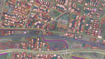
✓Producing 1:1000 to 1:5000 scale areial and corridor existing situation/ground contour maps (DTM) w/ aerial photograpy (photogrammetry) and terrestrial survey & sattelite images,
✓Infrastructure engineering projects, preliminary design, detail design, consultancy services and infrastructure construction supervising services,
✓Soil investigation activities and laboratory tests (agricultural, geological & getechnical services) for land consalidation Project, road, rail way and irrigation system design services.
✓Pipeline and Electrical Over Headline land clearence related feasibility study, corridor selection, survey mapping, preliminary/design work, RoW and tender out document preparations.
Main Client List of Çekül Co.:
✓General Directorate of Cadastre and Land Registre
✓Carrying out systematic first cadastre of agricultural and urban areas,
✓Modernisation/Renewing of existing low quality cadastre done without coordinate system in the past etc…,
✓Forest cadastre application
General Directorate Of Agricultural Reform
✓Land consalidation,
✓Digitisation of graphical cadastre drawing (KVK) and georeferencing with sattelite based produced ortho-photo mosaics,
✓To prepare country based land use clasification database for Ministry of Agriculture, We have been involved in the Land Parsel Identification System (LPIS) Project of Turkey.
Mining/Energy Industries Activities;
✓Topographical Services for 2D & 3D Seismic Data Acquisition System,
✓Crude Oil & Gas Production Field Surface Facilities Geographical Information System Planning, Design and Operating,
✓Pipeline Information System Planning, Design and Operating,
Municipalities;
✓Urban Information System Planning, Design and Operating,
✓Existing Situation Mapping (Contour / DTM) w/ Conventional - Terrestrial, Aerial Photogrammetry and Sattelite Image,
✓Interface Software Preparation, Database Designing for Daily Routine Municipalities Construction Permitting Works,
✓Designing Computer Aided Automation System for Monitoring / Follow Up Tax Etc…Payments.
General Directorate of High Way;
✓Corridor Definition/Analysing of New Road,
✓Corridor Survey/Mapping, 3D Modelling,
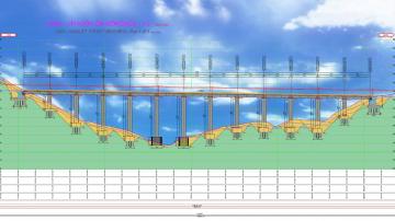
✓Corridor Investigation for Road/Bridge – Viaduct/Tunnel Design,
✓Rigt of Way (RoW) / Expropriation - Cadastre Plan & Document Preparation,
General Directorate of Hydroulic Works & Private Power Generation Co.
✓Survey/Mapping of Dam/Hydro Electrical Power Plant (HEPP) Site & Surface Structure Design Works and Main Access Roads (w/ 7m asphalt platform).
✓DTM/Ortho-Photo Creation w/ Aerial Photogrammetry, Expropriation-Cadastre Plan & Document Preparation for Land Acquisition to be used in constraction/social recreation activities, auxiliary facilities and dam reservoir area.
✓Preparing Resetlemet Action Plan (RAP) w/ GIS Application and Operating System on Behalf of Clients.
✓Batymetric Survey and 3D Mapping of River/Dam Lake & See Bed,
General Directorate of Pipeline Transportion;
✓Gas/Crude Oil Supply Pipeline Corridor Definition,
✓Earthwork Searching (Geological – Geotechnical Study),
✓Corridor 3D Mapping w/ aerial – terrestrial method,
✓Expropriation / cadastre (RoW) plan – work,
✓Route Resign / Plan Profile Preparation,
✓Tender out document preparation.